| at: |
Cashes Valley Trans North Georgia |
Data from David Muse
 show on map
 animate
Trail users:


Elevation Profile
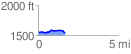
 1.666307 mi
 74.82 ft
 78.72 ft
 -3.90 ft
 0.89 %
GPX Downloads: Track Route
![]()
| at: |
Cashes Valley Trans North Georgia |
show on map
animate
1.666307 mi
74.82 ft
78.72 ft
-3.90 ft
0.89 %