| at: |
Panther Creek |
Data from David Muse
 show on map
 animate
Trail users:


Elevation Profile
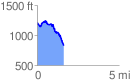
 1.623857 mi
 146.42 ft
 534.52 ft
 -388.10 ft
 6.23 %
GPX Downloads: Track Route
![]()
| at: |
Panther Creek |
show on map
animate
1.623857 mi
146.42 ft
534.52 ft
-388.10 ft
6.23 %