| at: |
Brawley Mountain Trans North Georgia |
Data from David Muse
 show on map
 animate
Trail users:


Elevation Profile
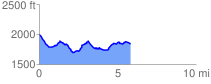
 5.930081 mi
 698.61 ft
 912.20 ft
 -213.59 ft
 2.91 %
GPX Downloads: Track Route
![]()
| at: |
Brawley Mountain Trans North Georgia |
show on map
animate
5.930081 mi
698.61 ft
912.20 ft
-213.59 ft
2.91 %