|
| at: |
Fort Ord Public Lands |
Data from David Muse
 show on map
 animate
Trail users:


Elevation Profile
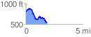
 1.847925 mi
 223.73 ft
 481.37 ft
 -257.64 ft
 4.93 %
GPX Downloads: Track Route
![]()
|
| at: |
Fort Ord Public Lands |
show on map
animate
1.847925 mi
223.73 ft
481.37 ft
-257.64 ft
4.93 %