| at: |
Fort Ord Public Lands |
Data from Jason Sager
 show on map
 animate
Trail users:


Elevation Profile
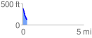
 0.353960 mi
 1.53 ft
 263.06 ft
 -261.53 ft
 14.08 %
GPX Downloads: Track Route
![]()
| at: |
Fort Ord Public Lands |
show on map
animate
0.353960 mi
1.53 ft
263.06 ft
-261.53 ft
14.08 %