| at: |
Fort Ord Public Lands |
Data from Jason Sager
 show on map
 animate
Trail users:


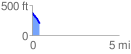
Elevation Profile
 0.434099 mi
 4.09 ft
 181.26 ft
 -177.17 ft
 7.91 %
GPX Downloads: Track Route
![]()
| at: |
Fort Ord Public Lands |
show on map
animate
0.434099 mi
4.09 ft
181.26 ft
-177.17 ft
7.91 %