| at: |
Fort Ord Public Lands |
Data from David Muse
 show on map
 animate
Trail users:


Elevation Profile
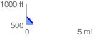
 0.575918 mi
 30.02 ft
 160.42 ft
 -130.40 ft
 5.28 %
GPX Downloads: Track Route
![]()
| at: |
Fort Ord Public Lands |
show on map
animate
0.575918 mi
30.02 ft
160.42 ft
-130.40 ft
5.28 %