| at: |
Fort Ord Public Lands |
Data from Jason Sager
 show on map
 animate
Trail users:


Elevation Profile
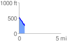
 0.653631 mi
 14.95 ft
 300.00 ft
 -285.05 ft
 8.69 %
GPX Downloads: Track Route
![]()
| at: |
Fort Ord Public Lands |
show on map
animate
0.653631 mi
14.95 ft
300.00 ft
-285.05 ft
8.69 %