| at: |
Fort Ord Public Lands |
Data from Jason Sager
 show on map
 animate
Trail users:


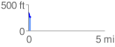
Elevation Profile
 0.172831 mi
 16.41 ft
 104.61 ft
 -88.19 ft
 11.46 %
GPX Downloads: Track Route
![]()
| at: |
Fort Ord Public Lands |
show on map
animate
0.172831 mi
16.41 ft
104.61 ft
-88.19 ft
11.46 %