|
| at: |
Fort Ord Public Lands |
Data from David Muse
 show on map
 animate
Trail users:


Elevation Profile
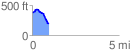
 0.965127 mi
 75.11 ft
 243.61 ft
 -168.50 ft
 4.78 %
GPX Downloads: Track Route
![]()
|
| at: |
Fort Ord Public Lands |
show on map
animate
0.965127 mi
75.11 ft
243.61 ft
-168.50 ft
4.78 %