| at: |
Fort Ord Public Lands |
Data from David Muse
 show on map
 animate
Trail users:


Elevation Profile
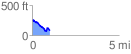
 1.000020 mi
 70.52 ft
 253.97 ft
 -183.45 ft
 4.81 %
GPX Downloads: Track Route
![]()
| at: |
Fort Ord Public Lands |
show on map
animate
1.000020 mi
70.52 ft
253.97 ft
-183.45 ft
4.81 %