| at: |
Fort Ord Public Lands |
Data from Jason Sager
 show on map
 animate
Trail users:


Elevation Profile
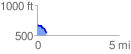
 0.573270 mi
 8.62 ft
 139.56 ft
 -130.94 ft
 4.61 %
GPX Downloads: Track Route
![]()
| at: |
Fort Ord Public Lands |
show on map
animate
0.573270 mi
8.62 ft
139.56 ft
-130.94 ft
4.61 %