|
| at: |
Fort Ord Public Lands |
Data from Jason Sager
 show on map
 animate
Trail users:


Elevation Profile
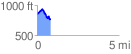
 0.806880 mi
 168.08 ft
 241.73 ft
 -73.65 ft
 5.67 %
GPX Downloads: Track Route
![]()
|
| at: |
Fort Ord Public Lands |
show on map
animate
0.806880 mi
168.08 ft
241.73 ft
-73.65 ft
5.67 %