| at: |
Fort Ord Public Lands |
Data from David Muse
 show on map
 animate
Trail users:


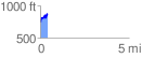
Elevation Profile
 0.422774 mi
 184.91 ft
 51.18 ft
 133.73 ft
 8.28 %
GPX Downloads: Track Route
![]()
| at: |
Fort Ord Public Lands |
show on map
animate
0.422774 mi
184.91 ft
51.18 ft
133.73 ft
8.28 %