| at: |
Fort Ord Public Lands |
Data from David Muse
 show on map
 animate
Trail users:


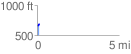
Elevation Profile
 0.142331 mi
 33.43 ft
 7.90 ft
 25.54 ft
 4.45 %
GPX Downloads: Track Route
![]()
| at: |
Fort Ord Public Lands |
show on map
animate
0.142331 mi
33.43 ft
7.90 ft
25.54 ft
4.45 %