| at: |
Fort Ord Public Lands |
Data from David Muse
 show on map
 animate
Trail users:


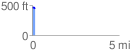
Elevation Profile
 0.155040 mi
 7.06 ft
 31.27 ft
 -24.21 ft
 3.82 %
GPX Downloads: Track Route
![]()
| at: |
Fort Ord Public Lands |
show on map
animate
0.155040 mi
7.06 ft
31.27 ft
-24.21 ft
3.82 %