| at: |
Forks Area Trail System Sumter National Forest - Long Cane District |
Data from David Muse
 show on map
 animate
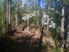
Trail users:


Elevation Profile
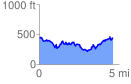
 4.639248 mi
 1286.52 ft
 1286.52 ft
 0.00 ft
 5.25 %
GPX Downloads: Track Route
![]()
| at: |
Forks Area Trail System Sumter National Forest - Long Cane District |
show on map
animate
4.639248 mi
1286.52 ft
1286.52 ft
0.00 ft
5.25 %