| at: |
Forks Area Trail System Sumter National Forest - Long Cane District |
Data from David Muse
 show on map
 animate

Trail users:


Elevation Profile
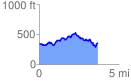
 3.705985 mi
 628.09 ft
 628.09 ft
 0.00 ft
 3.21 %
GPX Downloads: Track Route
Trailheads:
 FATS North Trailhead