| at: |
Northern Sierra Nevada - Downieville Area |
Data from David Muse
 show on map
 animate
Trail users:


Elevation Profile
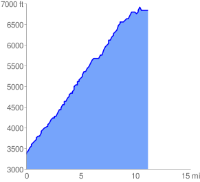
 11.252225 mi
 4293.01 ft
 806.78 ft
 3486.24 ft
 7.23 %
GPX Downloads: Track Route
![]()
| at: |
Northern Sierra Nevada - Downieville Area |
show on map
animate
11.252225 mi
4293.01 ft
806.78 ft
3486.24 ft
7.23 %