| at: |
Snow Basin Recreation Area |
Data from David Muse
 show on map
 animate
Trail users:


Elevation Profile
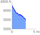
 2.831715 mi
 224.81 ft
 1051.84 ft
 -827.02 ft
 7.04 %
GPX Downloads: Track Route
Trailheads:
 Green Pond
![]()
| at: |
Snow Basin Recreation Area |
show on map
animate
2.831715 mi
224.81 ft
1051.84 ft
-827.02 ft
7.04 %
Green Pond