| at: |
Frank G. Bonelli Regional Park |
Data from David Muse
 show on map
 animate
Trail users:


Elevation Profile
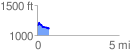
 0.744927 mi
 78.71 ft
 108.99 ft
 -30.28 ft
 2.77 %
GPX Downloads: Track Route
![]()
| at: |
Frank G. Bonelli Regional Park |
show on map
animate
0.744927 mi
78.71 ft
108.99 ft
-30.28 ft
2.77 %