| at: |
Frank G. Bonelli Regional Park |
Data from David Muse
 show on map
 animate
Trail users:


Elevation Profile
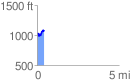
 0.441652 mi
 137.26 ft
 94.86 ft
 42.40 ft
 5.89 %
GPX Downloads: Track Route
![]()
| at: |
Frank G. Bonelli Regional Park |
show on map
animate
0.441652 mi
137.26 ft
94.86 ft
42.40 ft
5.89 %