| at: |
Frank G. Bonelli Regional Park |
Data from David Muse
 show on map
 animate
Trail users:


Elevation Profile
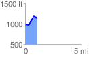
 1.079304 mi
 293.74 ft
 125.09 ft
 168.65 ft
 5.15 %
GPX Downloads: Track Route
![]()
| at: |
Frank G. Bonelli Regional Park |
show on map
animate
1.079304 mi
293.74 ft
125.09 ft
168.65 ft
5.15 %