| at: |
Frank G. Bonelli Regional Park |
Data from David Muse
 show on map
 animate
Trail users:


Elevation Profile
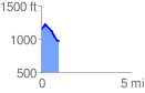
 0.982488 mi
 89.34 ft
 271.71 ft
 -182.37 ft
 5.24 %
GPX Downloads: Track Route
![]()
| at: |
Frank G. Bonelli Regional Park |
show on map
animate
0.982488 mi
89.34 ft
271.71 ft
-182.37 ft
5.24 %