| at: |
Forest Park |
Data from Jason Sager
 show on map
 animate
Trail users:


Elevation Profile
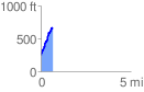
 0.652381 mi
 438.73 ft
 31.42 ft
 407.30 ft
 12.74 %
GPX Downloads: Track Route
![]()
| at: |
Forest Park |
show on map
animate
0.652381 mi
438.73 ft
31.42 ft
407.30 ft
12.74 %