| at: |
Forest Park |
Data from Jason Sager
 show on map
 animate
Trail users:


Elevation Profile
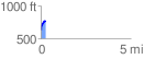
 0.254981 mi
 145.71 ft
 2.40 ft
 143.31 ft
 10.82 %
GPX Downloads: Track Route
![]()
| at: |
Forest Park |
show on map
animate
0.254981 mi
145.71 ft
2.40 ft
143.31 ft
10.82 %