| at: |
18 Road |
Data from Positive Flow
 show on map
 animate
Trail users:


Elevation Profile
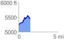
 1.514932 mi
 404.86 ft
 182.11 ft
 222.75 ft
 5.06 %
GPX Downloads: Track Route
![]()
| at: |
18 Road |
show on map
animate
1.514932 mi
404.86 ft
182.11 ft
222.75 ft
5.06 %