| at: |
Lajitas Trails |
Data from Jason Sager
 show on map
 animate
Trail users:


Elevation Profile
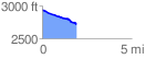
 1.943606 mi
 18.94 ft
 252.18 ft
 -233.24 ft
 2.46 %
GPX Downloads: Track Route
![]()
| at: |
Lajitas Trails |
show on map
animate
1.943606 mi
18.94 ft
252.18 ft
-233.24 ft
2.46 %