|
| at: |
Lajitas Trails |
Data from David Muse
 show on map
 animate
Trail users:


Elevation Profile
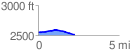
 2.252899 mi
 53.73 ft
 98.26 ft
 -44.53 ft
 0.83 %
GPX Downloads: Track Route
![]()
|
| at: |
Lajitas Trails |
show on map
animate
2.252899 mi
53.73 ft
98.26 ft
-44.53 ft
0.83 %