| at: |
Jackrabbit Trails |
Data from Positive Flow
 show on map
 animate
Trail users:


Elevation Profile
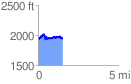
 1.548883 mi
 295.03 ft
 299.77 ft
 -4.73 ft
 3.67 %
GPX Downloads: Track Route
![]()
| at: |
Jackrabbit Trails |
show on map
animate
1.548883 mi
295.03 ft
299.77 ft
-4.73 ft
3.67 %