| at: |
Jackrabbit Trails |
Data from Positive Flow
 show on map
 animate

Trail users:


Elevation Profile
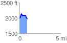
 0.937184 mi
 224.12 ft
 241.15 ft
 -17.03 ft
 4.87 %
GPX Downloads: Track Route
![]()
| at: |
Jackrabbit Trails |
show on map
animate
0.937184 mi
224.12 ft
241.15 ft
-17.03 ft
4.87 %