| at: |
Jackrabbit Trails |
Data from Positive Flow
 show on map
 animate
Trail users:


Elevation Profile
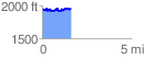
 1.614833 mi
 291.54 ft
 298.76 ft
 -7.22 ft
 3.50 %
GPX Downloads: Track Route
![]()
| at: |
Jackrabbit Trails |
show on map
animate
1.614833 mi
291.54 ft
298.76 ft
-7.22 ft
3.50 %