| at: |
Sherman Branch |
Data from Positive Flow
 show on map
 animate
Trail users:


Elevation Profile
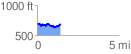
 1.450437 mi
 189.42 ft
 192.06 ft
 -2.65 ft
 2.51 %
GPX Downloads: Track Route
![]()
| at: |
Sherman Branch |
show on map
animate
1.450437 mi
189.42 ft
192.06 ft
-2.65 ft
2.51 %