| at: |
US National Whitewater Center |
Data from Positive Flow
 show on map
 animate
Trail users:


Elevation Profile
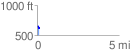
 0.143391 mi
 4.28 ft
 36.32 ft
 -32.04 ft
 4.80 %
GPX Downloads: Track Route
![]()
| at: |
US National Whitewater Center |
show on map
animate
0.143391 mi
4.28 ft
36.32 ft
-32.04 ft
4.80 %