| at: |
Paris Mountain State Park |
Data from Positive Flow
 show on map
 animate
Trail users:


Elevation Profile
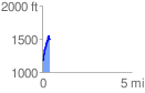
 0.434644 mi
 378.77 ft
 59.68 ft
 319.09 ft
 16.50 %
GPX Downloads: Track Route
![]()
| at: |
Paris Mountain State Park |
show on map
animate
0.434644 mi
378.77 ft
59.68 ft
319.09 ft
16.50 %