| at: |
Coopers Creek WMA Brawley Mountain Chestatee WMA |
Data from David Muse
 show on map
 animate
Trail users:


Elevation Profile
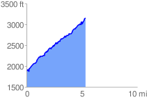
 5.375635 mi
 1690.55 ft
 406.54 ft
 1284.01 ft
 5.96 %
GPX Downloads: Track Route
![]()
| at: |
Coopers Creek WMA Brawley Mountain Chestatee WMA |
show on map
animate
5.375635 mi
1690.55 ft
406.54 ft
1284.01 ft
5.96 %