| at: |
Golden Gate Canyon State Park |
Data from Positive Flow
 show on map
 animate
Trail users:


Elevation Profile
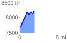
 1.776005 mi
 772.98 ft
 220.55 ft
 552.44 ft
 8.24 %
GPX Downloads: Track Route
Trailheads:
 Nott Creek
![]()
| at: |
Golden Gate Canyon State Park |
show on map
animate
1.776005 mi
772.98 ft
220.55 ft
552.44 ft
8.24 %
Nott Creek