|
| at: |
Houston Valley |
Data from USFS GIS
 show on map
 animate
Trail users:


Elevation Profile
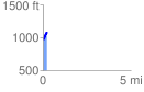
 0.215602 mi
 127.08 ft
 12.93 ft
 114.16 ft
 11.16 %
GPX Downloads: Track Route
![]()
|
| at: |
Houston Valley |
show on map
animate
0.215602 mi
127.08 ft
12.93 ft
114.16 ft
11.16 %