|
| at: |
Johns Mountain WMA |
Data from USFS GIS
 show on map
 animate
Trail users:

Elevation Profile
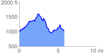
 6.141955 mi
 1388.61 ft
 1388.61 ft
 0.00 ft
 4.28 %
GPX Downloads: Track Route
![]()
|
| at: |
Johns Mountain WMA |
show on map
animate
6.141955 mi
1388.61 ft
1388.61 ft
0.00 ft
4.28 %