|
| at: |
Houston Valley |
Data from USFS GIS
 show on map
 animate
Trail users:


Elevation Profile
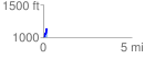
 0.207701 mi
 135.19 ft
 18.22 ft
 116.97 ft
 12.33 %
GPX Downloads: Track Route
![]()
|
| at: |
Houston Valley |
show on map
animate
0.207701 mi
135.19 ft
18.22 ft
116.97 ft
12.33 %