|
| at: |
Houston Valley |
Data from USFS GIS
 show on map
 animate
Trail users:


Elevation Profile
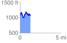
 1.279147 mi
 521.37 ft
 521.37 ft
 0.00 ft
 7.72 %
GPX Downloads: Track Route
![]()
|
| at: |
Houston Valley |
show on map
animate
1.279147 mi
521.37 ft
521.37 ft
0.00 ft
7.72 %