|
| at: |
Houston Valley |
Data from USFS GIS
 show on map
 animate
Trail users:


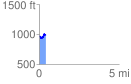
Elevation Profile
 0.428707 mi
 78.07 ft
 63.85 ft
 14.22 ft
 3.45 %
GPX Downloads: Track Route
![]()
|
| at: |
Houston Valley |
show on map
animate
0.428707 mi
78.07 ft
63.85 ft
14.22 ft
3.45 %