| at: |
Tray Mountain |
Data from USFS GIS
 show on map
 animate
Trail users:

Elevation Profile
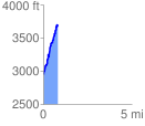
 0.802372 mi
 803.88 ft
 54.78 ft
 749.10 ft
 18.97 %
GPX Downloads: Track Route
![]()
| at: |
Tray Mountain |
show on map
animate
0.802372 mi
803.88 ft
54.78 ft
749.10 ft
18.97 %