|
| at: |
Beasley Knob |
Data from USFS GIS
 show on map
 animate
Trail users:


Elevation Profile
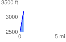
 0.484997 mi
 683.71 ft
 0.00 ft
 683.71 ft
 26.70 %
GPX Downloads: Track Route
![]()
|
| at: |
Beasley Knob |
show on map
animate
0.484997 mi
683.71 ft
0.00 ft
683.71 ft
26.70 %