|
| at: |
Beasley Knob |
Data from USFS GIS
 show on map
 animate
Trail users:


Elevation Profile
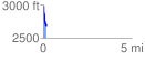
 0.179898 mi
 6.76 ft
 290.10 ft
 -283.34 ft
 30.54 %
GPX Downloads: Track Route
![]()
|
| at: |
Beasley Knob |
show on map
animate
0.179898 mi
6.76 ft
290.10 ft
-283.34 ft
30.54 %