| at: |
Chestatee WMA |
Data from USFS GIS
 show on map
 animate
Trail users:

Elevation Profile
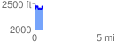
 0.550563 mi
 218.83 ft
 224.42 ft
 -5.59 ft
 7.72 %
GPX Downloads: Track Route
Trailheads:
 Dockery Lake Lot
![]()
| at: |
Chestatee WMA |
show on map
animate
0.550563 mi
218.83 ft
224.42 ft
-5.59 ft
7.72 %
Dockery Lake Lot