| at: |
Coopers Creek WMA |
Data from USFS GIS
 show on map
 animate
Trail users:

Elevation Profile
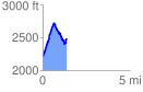
 1.412775 mi
 702.48 ft
 418.89 ft
 283.59 ft
 9.42 %
GPX Downloads: Track Route
Trailheads:
 Cooper Creek Recreation Area
![]()
| at: |
Coopers Creek WMA |
show on map
animate
1.412775 mi
702.48 ft
418.89 ft
283.59 ft
9.42 %
Cooper Creek Recreation Area