|
| at: |
Beasley Knob |
Data from USFS GIS
 show on map
 animate
Trail users:


Elevation Profile
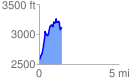
 1.403061 mi
 854.28 ft
 316.97 ft
 537.31 ft
 11.53 %
GPX Downloads: Track Route
![]()
|
| at: |
Beasley Knob |
show on map
animate
1.403061 mi
854.28 ft
316.97 ft
537.31 ft
11.53 %