|
| at: |
Beasley Knob |
Data from USFS GIS
 show on map
 animate
Trail users:


Elevation Profile
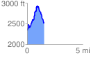
 1.521290 mi
 709.96 ft
 515.74 ft
 194.22 ft
 8.84 %
GPX Downloads: Track Route
![]()
|
| at: |
Beasley Knob |
show on map
animate
1.521290 mi
709.96 ft
515.74 ft
194.22 ft
8.84 %