| at: |
Coopers Creek WMA |
Data from USFS GIS
 show on map
 animate
Trail users:

Elevation Profile
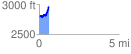
 0.633349 mi
 234.67 ft
 55.41 ft
 179.25 ft
 7.02 %
GPX Downloads: Track Route
![]()
| at: |
Coopers Creek WMA |
show on map
animate
0.633349 mi
234.67 ft
55.41 ft
179.25 ft
7.02 %